Amorgos at the forefront:
Greece’s first comprehensive fisheries reserve
On August 18, 2025, the visionary efforts of the fishers of Amorgos gained official institutional status. With the publication of Presidential Decree 73/2025, the proposals of the initiative AMORGORAMA were enacted into national law, establishing the island as an international benchmark for marine conservation.
The new institutional framework mandates three year-round no-take zones (Katapola, Gramvousa, Nikouria) and an island-wide two-month fishing closure every spring (April 1 – May 31, within 1.5 nautical miles of the coastline), initially for a five-year period. This measure aims to regenerate marine life and secure the future of small-scale coastal fishing for the decades to come.
This regulation applies to all types of fishing—both professional and recreational—with the goal of restoring severely depleted fish stocks and ensuring the viability of small-scale coastal fisheries on Amorgos.

Where do we stop fishing:
The “Lungs” of the Amorgos Sea
Permanent No-Take Zones (FRAs): For at least five years, the sea in the following areas remains untouched, 365 days a year:
These are “no-take” Fisheries Restricted Areas: this means that all professional and recreational activity is prohibited within these zones. No nets, no longlines, no rod-and-line, no spearfishing, no traps, and no recreational fishing are permitted.
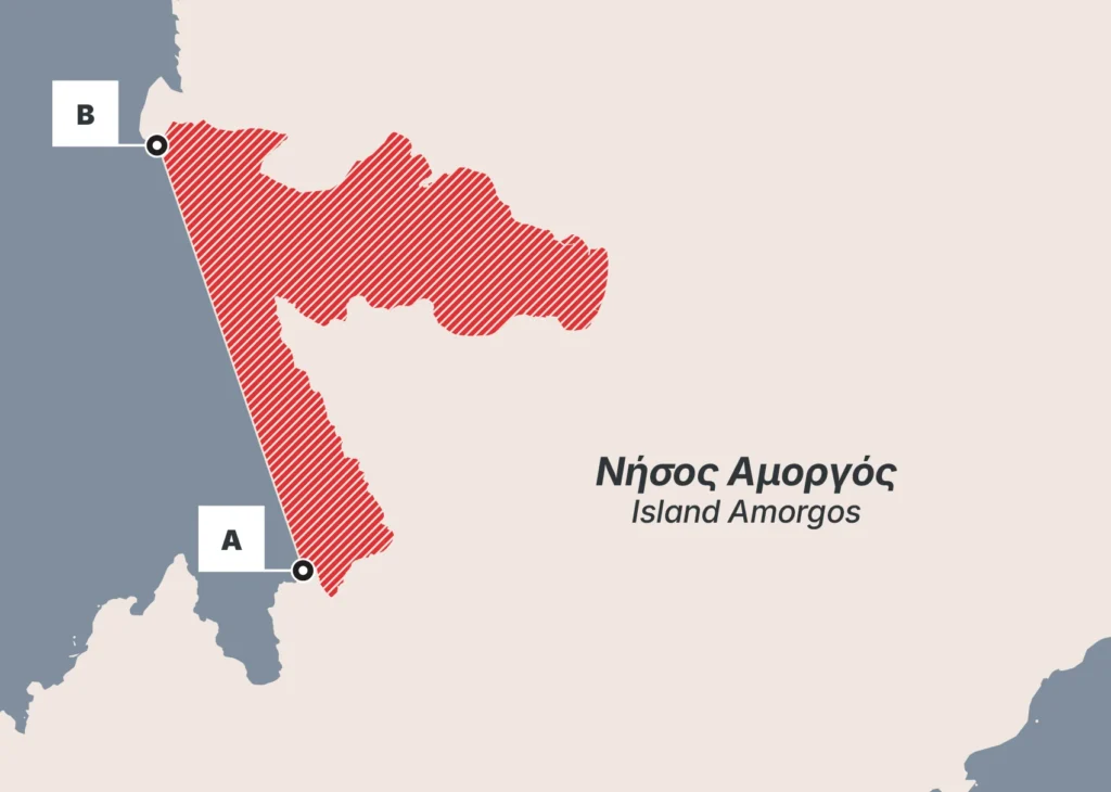
Katapola area
(surrounding the main port)
No-take Fisheries Restricted Area
| A | 36° 48' 54.6762" N | 25° 50' 53.0196" E |
| B | 36° 50' 8.7432" N | 25° 50' 21.4044" E |
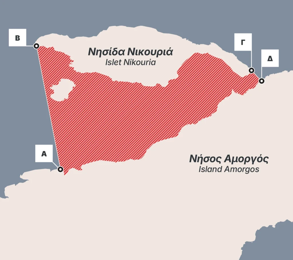
Nikouria islet
No-take Fisheries Restricted Area
| A | 36° 51' 52.6854" N | |
| B | 36° 53' 13.0452" N | |
| Γ | 36° 52' 57.1080" N | 25° 56' 5.7840" E |
| Δ | 36° 52' 50.6778" N | 25° 56' 13.4190" E |
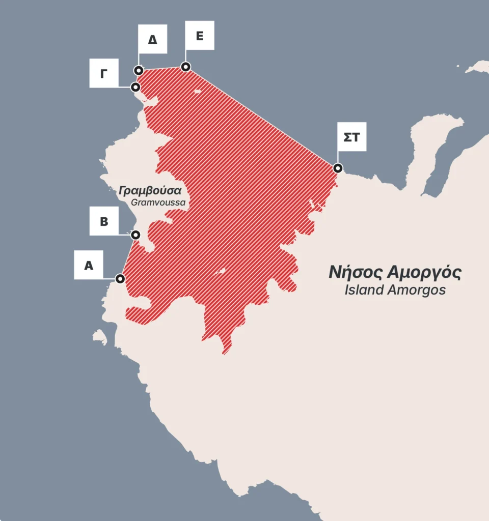
Gramvoussa islet
No-take Fisheries Restricted Area
| A | 36° 47' 48.8076" N | |
| B | 36° 48' 6.3648" N | |
| Γ | 36° 49' 3.7734" N | |
| Δ | 36° 49' 9.9300" N | |
| E | 36° 49' 11.4270" N | 25° 45' 5.3172" E |
| ΣΤ | 36° 48' 30.3294" N | 25° 46' 21.0756" E |
Seasonal “Rest” around the island
Every April and May, fishing is suspended within a 1.5-nautical-mile radius of the entire Amorgos coastline.
This is the peak spawning season, a period when nature requires tranquility to replenish its stocks.
Who is affected and how
| Category | Regulations |
|---|---|
| Professional Fishers | Professional coastal fishing is still permitted outside the three permanent no-take zones in Katapola, the Nikouria and Gramvousa islets, and beyond the April–May closure, but under stricter rules and with special permits for certain activities within the coastal zone (1.5 n.m.). Violations of the FRAs regulations may result in severe monetary fines, the revocation of the captain’s and vessel’s fishing licenses, and the confiscation of fishing gear and illegal catches. Furthermore, depending on the severity of the infringement, demerit points may be imposed in accordance with current fisheries legislation (Legislative Decree 420/1972 and Ministerial Decision 3866/78486/2015). The law prioritizes low-impact small-scale fishing, supports traditional kaikia, and discourages practices that damage habitats or target juvenile fish. |
| Amateurs & Visitors | Rod-and-line fishing (from boat or shore), spearfishing, and all other forms of recreational fishing are fully prohibited within the three permanent no-take zones year-round, as well as everywhere within 1.5 n.m. of the coast during April and May. Visitors and residents are kindly requested to respect these boundaries and to fish only in permitted areas and periods, in accordance with Greek national regulations. |
Seabed Protection:
Anchoring with respect for Posidonia
It is of paramount importance to protect Posidonia meadows from anchoring by tourist and recreational vessels.
These marine ecosystems, classified as priority marine habitat types at the European level, are critical breeding and feeding grounds for many marine organisms and fish, serving as nurseries for numerous commercial species.
Anchors and chains dropped onto these meadows cause extensive mechanical damage, scarring, and destruction of the seagrass, creating large clearings that lead to degradation and, ultimately, their death.
Vessel captains must avoid dropping their anchors on Posidonia meadows, both within and outside the Amorgos FRAs.
Surveillance and Scientific Monitoring:
Surveillance and enforcement at sea
An all-weather Coast Guard vessel has been assigned to Amorgos to oversee the new no-fishing zones and seasonal closures.
The FRA network will be monitored for at least five years, combining patrols, scientific surveys, and, where required by national policy, vessel tracking systems. This ensures that the benefits for fish stocks and fishers are documented and can be used as a model for other Greek islands.
Why we made this decision:
To fill the nets again
Local fishers reported a decline in catches of up to 90% over 20 years, with rising fuel and gear costs making their profession unsustainable. AMORGORAMA responds to this crisis by temporarily reducing fishing pressure, allowing fish populations and habitats to recover, and aiming for more stable catches and income in the medium and long term.
Protecting the Nurseries of the sea
The completion of the fisheries scientific study conducted by the Agricultural University of Athens confirmed the three permanent no-take zones and the 1.5-mile coastal zone—which had been proposed by the Professional Fishing Association of Amorgos—as key spawning and nursery grounds for important commercial species.
The Spillover Effect
By protecting the core, we allow larger, more fertile fish to reproduce and “spill over” into surrounding fishing grounds, increasing catches outside the FRAs over time.
AMORGORAMA is the proof that—when local knowledge meets science and political will—marine life regains its lost balance.